Mason Scholte and Jitte Waagen
Introduction
In a previous blogpost we introduced ARCfieldLAB, a research project aiming at creating an inventory of the most important technological innovations of the last ten years in the field of archaeological remote sensing, and disseminating this knowledge to improve the quality of archaeological fieldwork and research in the Netherlands. In this blogpost, we provide an update on the achievements of the past few months, the current state of the ARCfieldLAB project and the progress over these past few months.
Achievements and Progress
Filling the knowledge base
The first of the two main components of the ARCfieldLAB project is the creation of an online knowledge base on innovative sensor technologies. In the course of the project, an extensive literature review has provided an overview of many ground-based, water-based, aerial, and satellite-based sensor technologies being used at the cutting-edge of international archaeological research. To highlight the value and potential of these sensor technologies for their application in the field of Dutch archaeology, as well as to provide an overview of resources and best-practices, several of these sensor technologies will be described in detail by ARCfieldLAB knowledge partners in the future knowledge base.
In the same vein, several case studies will take place to apply these innovative sensor technologies in Dutch contexts, both on land or in the water. The focus of these case studies is on ‘benchmark sites’: archaeological sites where the focus is explicitly on the application of various sensor technologies in combination. This will provide comparative opportunities that can provide validation of results, as well as a frame of reference to compare the strengths and limitations of each individual sensor. Further importance is placed on how these novel methods fit into the current AMZ-cyclus (the Dutch archaeological heritage management cycle).
For both the description of the innovative sensor technologies and the case studies, a call for projects was distributed to come into contact with potential knowledge partners. From the applications, a selection was made by the core consortium. The following knowledge partners were selected:
- GAIA Prospection will be comparing the strengths of several different types of ground-based magnetometers at the site of a burial mound alignment in the province of Gelderland where various other geophysical techniques have taken place.
- As part of a larger survey, Periplus Archeomare will be conducting a novel drone magnetometry survey on a sunken village in the province of Zeeland. Periplus Archeomare will also be responsible for the description of several maritime techniques: the sub-bottom profiler, side scan sonar, and multi-beam sonar.
- Together, GAIA prospection and Periplus Archeomare will create the sensor technology description of magnetometry for both ground and water contexts.
- ArcheoPro will return to one of their long-standing test locations for geophysical techniques in the south of Limburg at the site of a late medieval farm and conduct surveys using a wide array of sensors.
- ArcheoPro is also performing a geophysical investigation in the center of a modern city to identify the medieval urban context underneath. This unique location provides a perfect opportunity to experiment with geophysical sensors in a highly complex sitecontext.
Several of the sensor descriptions and case studies are to be covered by knowledge partners from within the core consortium.
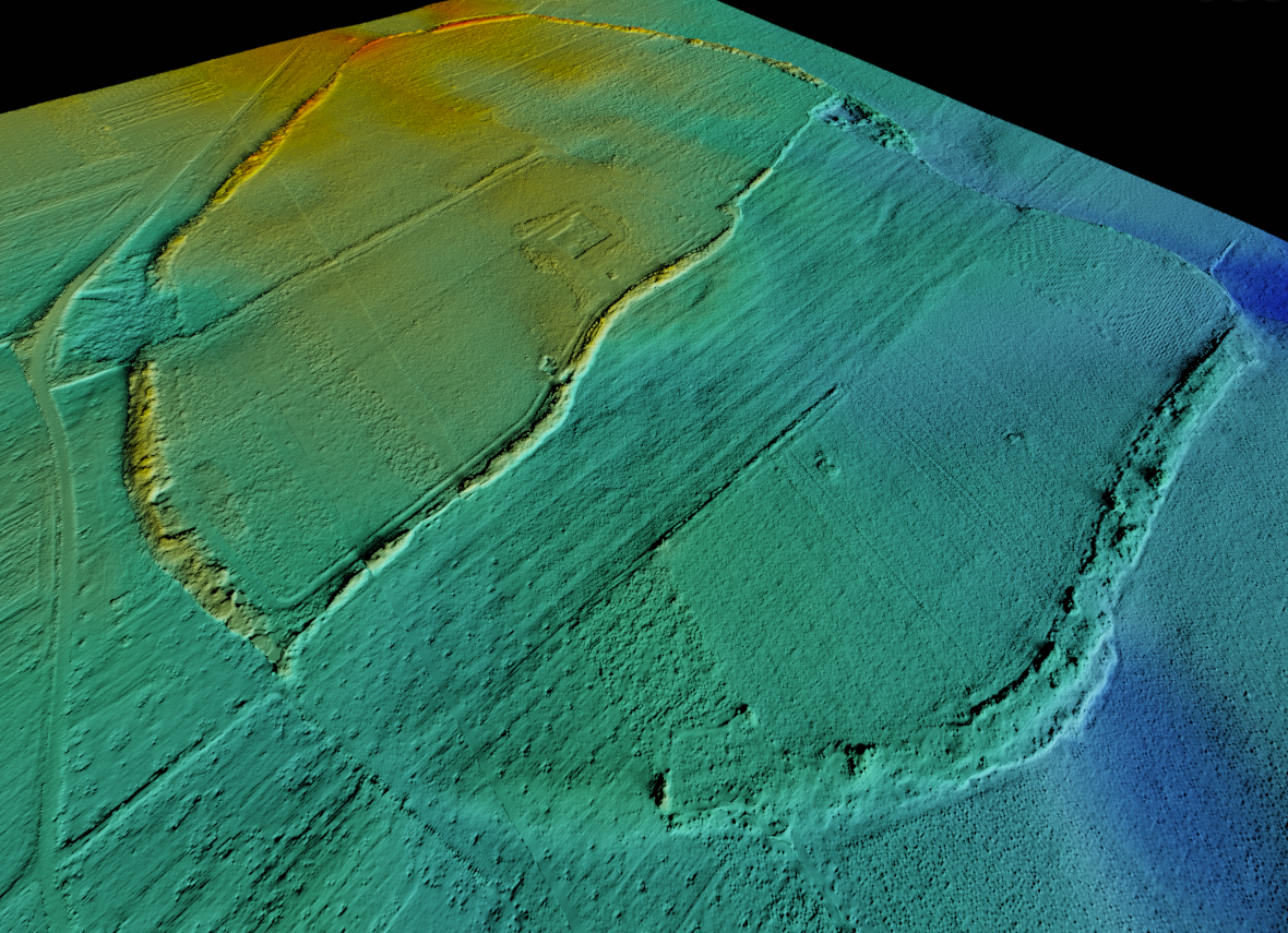
- The 4D Research Lab will be continuing their multi-sensor drone-based investigation into the site of a 13th c. AD castle in Noord-Holland and a Late Medieval farmstead in Friesland to further identify the environmental factors which influence the visibility of archaeological features. Given their expertise in applying thermography, the 4DRL will produce that sensor technology description.
- Wouter Verschoof-van der Vaart will be advancing the application of the Dutch national LiDAR dataset in archaeological heritage protection through the use of change detection at various known sites in the Netherlands. The sensor technology description of LiDAR will similarly be produced by him.
- Saxion will provide the technique descriptions for drone photogrammetry and multispectral research, as well as contribute to a yet-to-be-determined case study.


First expertmeeting
The second of the two main components of ARCfieldLAB is the organization of a series of expert meetings. The goal of these meetings is to promote the formation of multi-disciplinary networks and knowledge exchange collaboration between various sectors: archaeological professionals and academics, both from Dutch and international contexts, as well as remote sensing experts outside of the archaeological field.
On the 25th of April, the first of these expert meetings took place at the Bushuis at the University of Amsterdam. The goal of this meeting was to identify the needs and requirements for the online knowledge base, identify currently underexposed remote sensing techniques or sectors of untapped knowledge partners, and gain feedback on the direction of the project as a whole. All in all, the meeting was a great success and provided the opportunity for many interesting discussions. Various points were raised on the need for a decision support tool for sensor technologies, the importance of FAIR-data, and how sustainability of the project could be ensured after the project end date.
Looking forward
Second expertmeeting
On September 29th the second ARCfieldLAB expert meeting will take place at the Rijksdienst voor het Cultureel Erfgoed (RCE). The theme of this meeting will be ‘sustainable archaeological information structures’. The importance of this topic was highlighted in the first expert meeting. As ARCfieldLAB is involved in such a rapidly evolving field, it is important that the information provided is kept up-to-date throughout the project runtime. Furthermore, it is essential that there are plans in place for the maintenance and availability of the knowledge base after the project's duration ends. The focus of this meeting is therefore on how the information generated by the project can be made sustainable, and in what way this can be achieved through effective collaboration with the various E-RIHS projects. Stakeholders, experts on data management and sustainability, and members of related E-RIHS projects have been invited to discuss these issues.
Reuvensdagen
The sharing of knowledge is a vital part of the ARCfieldLAB project. For this reason, ARCfieldLAB will be showcased at the Reuvensdagen, the annual Dutch archaeological congress which brings together professionals, researchers, and other individuals interested in archaeology, within the context of a broader session on the various E-RIHS projects. The goal of this showcase is to increase the visibility of this project and obtain feedback to better integrate the final results with the current (and future) KNA (Knowledge Infrastructure in Dutch archaeology). The Reuvensdagen take place on the 16th and 17th of November in Hoorn. Interested? Find more information and tickets on the Reuvensdagen website!